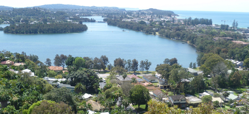
The Northern Beaches is home to 5 stunning coastal lagoons or estuaries:
• Narrabeen Lagoon
• Manly Lagoon
• Dee Why Lagoon
• Curl Curl Lagoon
• Pittwater
Each waterway is naturally dynamic, opening and closing naturally depending on rainfall and ocean conditions.
Our waterways are home to a wide variety of plants and animals too, specially adapted to a mix of freshwater and saltwater conditions. However, these fragile ecosystems can be upset by stormwater pollution, unauthorised lagoon openings and an imbalance of freshwater or ocean water.
Northern Beaches Council carefully manages each waterway. Protecting these fragile environments is an ongoing challenge that requires community awareness and care.
Water Quality
NSW Beachwatch the authority on managing recreational water, monitors water quality for swimming at our ocean beaches and 2 sites at Narrabeen Lagoon, weekly. Water quality for swimming is not monitored at Many, Curl Curl and Dee Why lagoons.
Tips to help avoid getting sick
- Avoid swimming at ocean beaches during and for one day after heavy rain. Check Beachwatch daily forecast for updates.
- Exercise caution or avoid swimming in our lagoons, especially after heavy rain. Please note that daily weather updates for the lagoons are not provided.
- Don’t swim if you notice discoloured water, fast flowing or strong smelling water or litter such as drinking straw and food wrappers, or leaves floating in the water or on the tide line.
Pollution sources
Stormwater runoff from roads, roofs and carparks flow into our creeks and lagoons before reaching the ocean. Pollution can come from households too.
Ways you can help reduce water pollution
Protecting our waterways is a shared responsibility.
• Never pour chemicals down the drain
• Use garden chemicals minimally and responsibly
• Don’t sweep leaves down the drain
• Reduce the use of other chemicals, like car shampoo
Lagoon health checks
We regularly monitor all 5 waterways for ecological health and produce an annual report card comparing their condition to other NSW lagoons.
Pollution sources
Stormwater, or rainwater run off, from our roads, footpaths and carparks flows into creeks, estuaries and coastal lagoons and finally to the ocean.
Pouring chemicals down the drain, using herbicides, pesticides and fertilisers in the garden all harm our waterways.
Sweeping leaves down the drain, washing the car on the driveway and using chemical products around the home all damage the water quality in our creeks, lagoons and beaches.
Lagoon flooding
During heavy rain, our local lagoons can fill up like a bathtub, leading to potential flooding of nearby properties and land.
To help protect the community and properties, Council carefully monitor and manages the lagoon entrances. When the water in each lagoon reaches a specific level, we will mechanically open the entrance to let the water drain into the sea.
Current opening levels for each lagoon:
- Narrabeen Lagoon 1.0-1.3m AHD
- Dee Why Lagoon 2.2m AHD
- Curl Curl Lagoon 2.2m AHD
- Manly Lagoon 1.4m AHD
Attempting to opening lagoons below these levels is usually unsuccessful and harms the local ecosystem. The decision to open a lagoon also depends on other natural factors like forecast rainfall, tide, ocean swell and the height of the sand berm at the entrance. Even with very heavy rainfall and/or strong ocean swell, mechanically opening the lagoon may not prevent flooding.
Flood warnings
Council in partnership with Manly Hydraulics Laboratory and the NSW Government provide a flood warning webpage tool that provides real-time information on rainfall conditions and water levels in a number of our creeks and lagoons.
Follow the Emergency Dashboard for advise on how to prepare, respond and recover from a weather event.
Unauthorised lagoon openings
Unauthorised lagoon openings are both illegal and highly dangerous. Strong water outflows often develop into standing waves, with particularly dangerous downward pressure. This can trap even the strongest of swimmers.
Additionally, after heavy rains, water may be contaminated and carry serious health risks to humans and marine life.
Unauthorised lagoon opening carries fines up to $1,100.
Understanding how we manage our lagoons
How does Council manage Narrabeen Lagoon entrance?
Narrabeen Lagoon naturally opens and closes to the ocean depending on how much sand has accumulated in the entrance and how much rain we’ve had. During the last 7 years the volume of sand at the northern end of Collaroy-Narrabeen Beach has significantly increased to the point where North Narrabeen is the widest it has been for decades. The sand drift cycles (long-shore drift) have pushed more sand in front of the entrance and there hasn’t been sufficient rainfall to clear it.
Council has two main methods of managing the entrance: mechanical break outs and entrance clearance.
If the lagoon has closed and there is potential flooding forecast, Council can undertake a mechanical break out where a channel is formed using an excavator, allowing the lagoon to drain out to the ocean. Break outs are more likely to be successful when the water level in the lagoon is at least 1 metre higher than mean sea level, with significant rainfall occurring or forecast. Otherwise the inflow from the ocean on high tide overcomes the outflow from the lagoon and it closes again.
Even after a successful breakout, the lagoon can close up again quite quickly if there is unfavourable swell and rainfall conditions, particularly with the current large width of North Narrabeen Beach. As such, this is only a short term management option undertaken primarily for flood mitigation. This is also how other coastal lagoons on the Northern Beaches are managed, however Dee Why and Curl Curl Lagoons are not opened until the water level is over 2m above mean sea level, which means they open with a much greater amount of energy and flow. As with Narrabeen, they stay open until the ocean sand closes them again.
The second management action is an entrance clearance where a large amount of sand is excavated from the entrance area, from the shoal west Ocean Street Bridge through to the ocean, and transported back to Collaroy-Narrabeen beach. This reduces the sand constriction in the entrance and helps to keep the lagoon open for a number of years (depending on ocean and rainfall conditions).
When is the next entrance clearance?
Council excavates the entrance area every few years, with clearance operations taking a few months each time. This is a long term management options and requires significant planning and funding. It was last completed in November 2023 and prior to that, in December 2021 and December 2018. The next entrance clearance works are planned for September - December 2025.
Clearance has been required more frequently in recent years as we have been in a period of clockwise beach rotation. Beach rotation is a decadal cycle, where clockwise rotation results in a wider beach and a higher volume of sand at the northern end of the beach, caused by changes in wave currents moving increased volumes of sand northwards along the beach.
How does Council reduce flooding?
Council monitors the water level and lagoon entrance conditions through site inspections and digital water level recorders, which are publicly available through Manly Hydraulics Laboratory.
Once water levels are high enough and rain is forecast, a mechanical breakout can be undertaken in line with mechanical breakout guidelines. In most cases this will allow the lagoon to drain and reduce the risk of flooding. In heavy weather conditions however, many properties may be prone to flooding even when the entrance is open because:
- The volume of water flowing down from the catchment can be held back by high ocean levels
- Heavy ocean swells and extreme tides can result in such high ocean levels that huge volumes of water can flow into the lagoon and cause flooding even without much rainfall
- Some properties are very low lying
When will Council next mechanically break out the entrance?
If the lagoon has closed and there is potential flooding forecast, Council can undertake a mechanical break out where a channel is formed using an excavator, allowing the lagoon to drain out to the ocean. Break outs are more likely to be successful when the water level in the lagoon is at least 1 metre higher than mean sea level, with significant rainfall occurring or forecast. Otherwise the inflow from the ocean on high tide overcomes the outflow from the lagoon and it closes again.
Council aims to manage the entrance in a way that balances community needs, flood risk and the need to maintain the natural process of a coastal lagoon (which includes periodic closure).
What were the findings of the Narrabeen Lagoon Entrance Management Strategy?
The final adopted strategy includes a range of priority actions which we will now begin to implement including:
- trialling more frequent but smaller sand clearance operations (every two-three years rather than four-five years)
- developing a more flexible set of the conditions which trigger Council intervention to open the lagoon if required
- adjusting the alignment for the pilot channel
- reshaping and revegetating the denuded part of Birdwood Park dune to assist with sand stabilisation
- investigating the financial viability of mobile sand pumping as a longer term alternative to trucking.